In February 2023, Cyclone Gabrielle overwhelmed Te Karaka's flood protection scheme, overtopping stopbanks in multiple locations. While the stopbanks did not fail, the flooding caused significant damage and disruption across the community.
In response, Council is working in partnership with Te Aitanga-a-Māhaki to upgrade and improve flood protection for the township, with support from government funding.
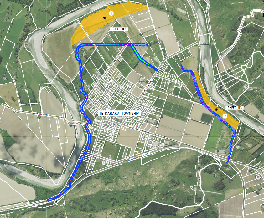
Project overview
This project will upgrade the existing flood control scheme protecting Te Karaka township to algin with the level of service being delivered through the downstream Waipaoa stopbank upgrades. The upgraded scheme is designed to manage a 5,625 cumec flood event.
For comparison, Cyclone Gabrielle was estimated by NIWA to have produced a peak flow of approximately 4,000 cumecs.
The Council-approved design includes:
- raised stopbanks
- stopbank retreat in the north and east of the scheme
- full culvert renewals
- floodgates
- raising the state highway in 2 locations
- double culvert extension at the state highway (upstream end)
- raising local roads in 1-2 locations
- other associated works.
Together, these improvements will deliver a higher level of flood protection and resilience than existed before Cyclone Gabrielle.
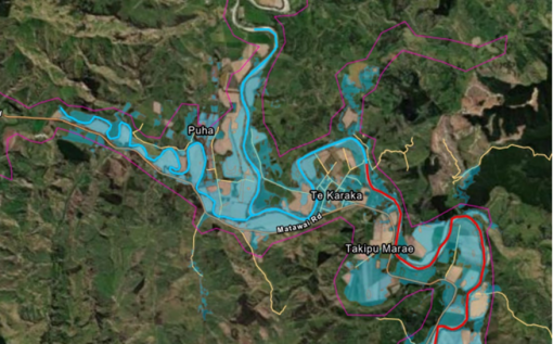
Te Karaka
Te Karaka township is home to approximately 179 households, 12 commercial properties and a population of around 525. During Cyclone Gabrielle, flooding affected a large area of the township. Across an area of 187 hectares, 60 dwellings are categorised at FOSAL Category 2.
The existing flood control scheme does not account for climate change and is currently susceptible to significant flooding. This presents a major risk to people and property living and working in the Te Karaka area.
What's happening now?
Resource consent
The resource consent application was submitted on 22 April 2026. It will be publicly notified and all consent documents will be made available on our website
Project funding
Council has approved the allocation of the full project budget of $27.6 million. This includes contingency to address potential cost increases such as fuel price escalation. Major cost components include:
- stopbank construction
- road raising works
- property acquisition and compensation
Final approval of funding is still required from government ministers.
Property negotiations
Discussions are underway with all property owners directly affected by the proposed stopbank alignment. Some property valuations are in progress to support fair agreements between Council and landowners.
Design and delivery
Detailed design is well underway to support the procurement of construction contracts.
Long-term reality - emergency readiness essential
Even with the proposed upgraded stopbank, Te Karaka will still face risk during very large flood events. When water levels at Kanakanaia Bridge reach around 8.5m, vehicle access on State Highway 2 towards Gisborne city is cut off — well before the current stopbank crest of 11.4m. This lag means residents may be isolated while flood risks continue to increase during an event (if evacuation has not occurred).
Maintaining community awareness, proactive evacuation planning and ongoing Civil Defence readiness is essential to mitigate these risks.
Planning controls
With changing climate conditions and updated flood data, it's likely that future planning rules will become stricter in high-risk flood areas. The government has signaled that additional funding may require Council to consider planning and building restrictions for high-risk properties. This is to reduce future damage if floods exceed the stopbank capacity.
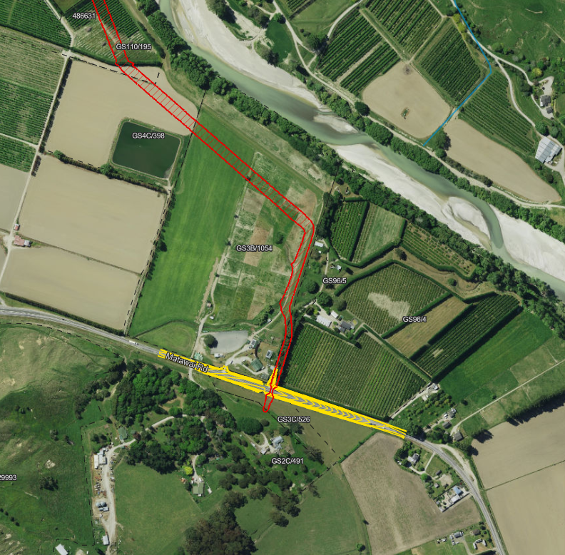
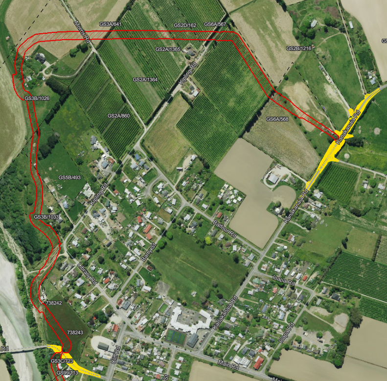
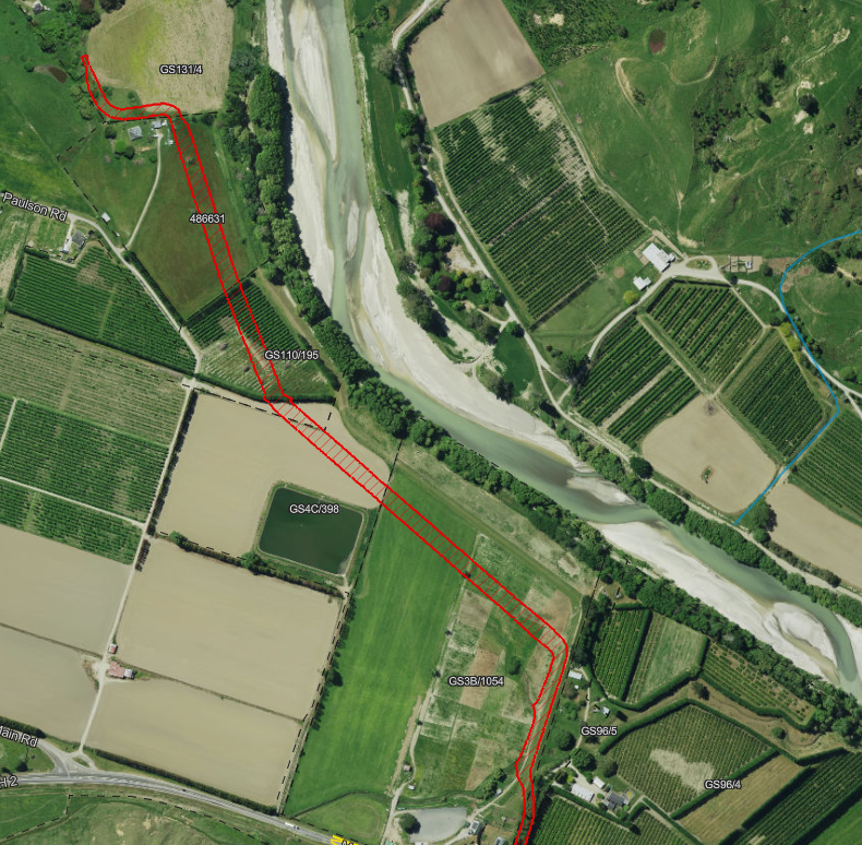
Stopbank alignment
We're seeking resource consent for 2 variations of the stopbank alignment. These variations reflect what the community and councillors endorsed, with refinements to allow flexibility for site-specific considerations during detailed design and delivery.
Engagement timeline
13 April 2024 - Community hui
Presented the partially calibrated flood model outputs for validation. Attendees were invited to provide feedback during the hui.
July 2024 - Steering Group formation
A Te Karaka community-led steering group of approx 20 members was established, with representation from Lavenham and Branson roads, along Matawai Road (from the Lavenham Rd junction through to Te Karaka township and up to Mangamaia Road, Whatatutu).
7 August 2024 - Steering Group hui #1
The inaugural meeting of the Steering Group was held. Group tikanga and purpose were established. The calibrated Cyclone Gabrielle flood model was presented and discussed. Two modelling scenarios were introduced and members were invited to bring additional scenarios to the next hui.
13 August 2024 – Community hui
An update on the formation and progress of the Steering Group was shared with the community as part of a wider recovery-focused hui.
31 August 2024 – Steering Group hui #2
A representative from DHI (modelling specialist) attended. The Steering Group shared firsthand experiences of flooding in Te Karaka and surrounding areas. Results of three modelled scenarios were presented, and additional scenarios for analysis were identified.
27 March 2025 – Community hui
The concept of retreating the stopbank alignment was introduced early. At least seven longlist alignment options were discussed.
30 April 2025 – Community hui
Four shortlisted alignment options were presented for community consideration and feedback.
29 June 2025 – Community hui
Two final alignment options were presented and discussed. The Council webpage and online submission portal were also promoted.
24 July 2025 – Community workshop
A drop-in hui where an adjusted alignment, based on community feedback at that time, was presented for discussion. Attendees were encouraged to complete online feedback before the closing date.
28 July 2025 – Online feedback closed
The Council webpage and submission form for community feedback closed at 9am.
17 August 2025 – Community hui
Te Aitanga-a-Māhaki and Council shared the Te Karaka Flood Resilience Improvement Report ahead of discussion at the 21 August 2025 Council meeting.
22 September 2025 – Resident hui
Three hui were held for residents outside the Te Karaka township (Lavenham/Branson Road, Takipu marae area, and Tapuhikitia Road/Bridge Lane). These were held at residents’ request to discuss potential impacts of the proposed stopbank alignment.
10 December 2025 – Community hui
Te Aitanga-a-Māhaki, Council and TREC provided updates on several recovery work programmes, including Te Karaka Flood Resilience. Funding challenges and steps being taken to address these were discussed, along with next steps including resource consent.
12 March 2026 – Affected property owner hui
The purpose of this hui was to inform property owners directly affected by the proposed stopbank design about land access and the compensation process.
The Property Group (represented by Gareth Nicholl) was introduced as independent property consultants supporting owners. The statutory framework, negotiation process, and property owner rights under the Public Works Act were outlined.
18 March 2026 – Bridge beneficiaries hui
Provided an update for bridge beneficiaries on the proposed stopbank project, including design, funding, and potential impacts on the Rangatira and Kanakanaia bridges. Landowners were able to ask questions and discuss risks, access, and mitigation options.
Note: “Bridge beneficiaries” refers to landowners living on the far side of the Kanakanaia and Rangatira bridges from Te Karaka township who rely on these bridges.
22 March 2026 – Community hui
A community recovery update was provided, including progress on the Te Karaka stopbank programme. Project costs had been refined, funding prospects were improving, and resource consent was confirmed to be lodged in April and likely notified. Updates on bridge impacts and design adjustments were also shared.
Project timeframe
These timeframes are indicative and may shift depending on approvals, funding and consent processes.
Stage 1 – Investigations - ✅ Completed
- Mid-2025: Preferred upgrade option identified
- 21 August 2025: Preferred option endorsed by Council
Stage 2 – Planning and approvals - late 2025 onwards
- Lodged application for resource consent April 2026
- Confirm project funding
- Note: There are risks associated with gaining resource consent approvals
Stage 3 – Construction - subject to consent approval
- Mid-2026: Begin procurement process
- Late 2026/27: Construction starts
- Estimated 2-year timeframe to complete the scheme upgrade